Coronavirus Cymru
Y Coronavirus Yng Nghymru
SCROLL DOWN FOR ENGLISH VERSION
Da ni yng nghanol cyfnod hollol unigryw yn hanes Cymru. Mae’ ysgolion i gyd wedi cau, busnesau wedi cloi a mae’r poblogaeth i gyd o dan lockdown.
Y coronavrus ydi’r unig stori sydd yna ar y newyddion, ond, fel sy’n digwydd yn rhu aml, mae’r rhan fwyaf o’r straeon, ffigyrau a gwybodaeth da ni’n gael yma wedi ei ffiltro unai drwy berspectif Prydeinig, neu Lloegr.
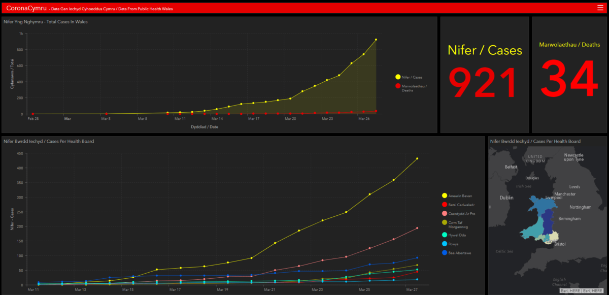
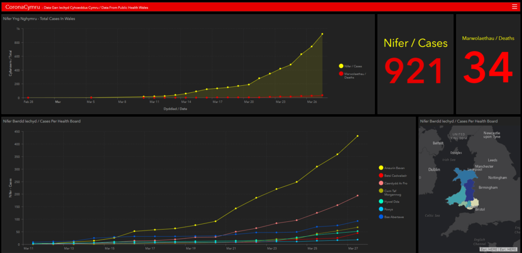
Ar ddechrau’r pandcmic, fe greodd Public Health England ddashffwrdd rhyngweithiol er mwyn i’r cyhoedd gael dilyn y datblygiadau. Yn anffodus, chawson ni ddim byd tebyg gan Iechyd Cyhoeddus Cymru (ICC), felly nes i benderfynu creu un fy hun!

Cliciwch Yma I Agor Y Dashboard
Data Ac Adnoddau
Er mwyn creu’r dashfwrdd, roedd rhaid i mi gasglu’r holl ffigyrau oedd wedi cael eu rhyddhau gan ICC i un lle. Dwisho rhannu’r data yna wan fel bod o ar gael i unrhyw un.
Isod dwi wedi rhestru bob dim dwi wedi defnyddio i greu’r dashfwrdd, a mi wnai drio diweddaru popeth cyn gynted y fydd data newydd ar gael.
Dwi’n meddwl fod hi’n bwysig bod y data yma ar gael i unrhywun ei ddadansoddi, ddylunio ac astudio.
Tablau Data
Dwi wedi rhoi’r data mewn Google Sheets. Fedrai ddiweddaru nhw wedyn yn hawdd. Mae’r data yn wreiddiol o’r dudalen yma LINC.
(O.N. – Yn y cychwyn, roedd y data yn cael ei rhyddhau ar lefel sirol – ond newidwyd hyn i lefel Byrddau Iechyd wedyn. Dyna dwi wedi gynnwys yma)
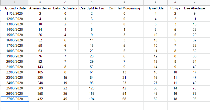
Data Lefel Bwrdd Iechyd
Hwn di’r data sydd yn cael ei ddiweddaru gan y ICC.

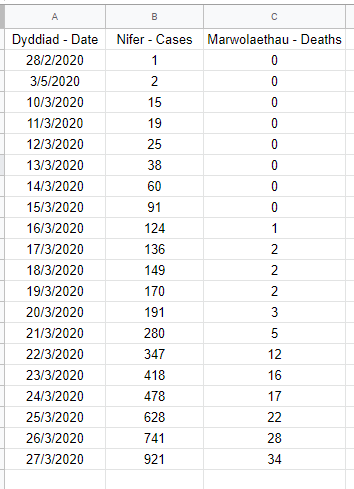
Data Lefel Gwlad
Crynhoad o’r data uchod ar lefel Cymru, yn cynnwys marwolaethau.
(O.N. Di’r data ddim yn gyflawn cyn 10/03/2020)

Mapiau
Dwi wedi bod yn mapio’r data yma ar lefel Byrddau Iechyd. Mae’r data daearyddol yma ar gael i lawrlwytho am ddim o wefan yr ONS (LINC)

Mae modd lawrlwytho y data yn syth o’r ddolen uchod mewn ffyrf shapefile neu kml. Ma na hefyd ffrydau data agored ar gael yna.
Gobeithio bod y stwff yma o fydd i rhywun. Gadewch fi wybod os di rhywbeth ddim yn glir, ne da chi isho help hefo rwbath.
Hwyl am y tro
Dafydd
Cronavirus In Wales
We are currently in the middle of an unprecedented period in Welsh history. All of our schools are shut, businesses are closed, and the population is in lock-down.
The coronavirus is the only story on the news, but, as often happens to us in Wales, a lot of the stories and information we get are filtered either through a British perspective, or an English one.
At the star of the pandemic, Public Health England created an interactive dashboard to keep the public informed of the development of the virus. We didn’t get the same from Public Health Wales (PHW), so I decided to make my own!

Data And Resources
To create the dashboard, i had to collate all the PHW data into one place (my arcgis online account). I now want to make this data available to everyone.
Below, I’ve included everything I’ve used to build the dashboard. I’ll try and update it asap as new data is released.
I think i’ts important that this data is accessible for anyone to analyse, visualise and study
Data Tables
I’ve copied the data over to Google Sheets. These are easy to use and allows me to update them easily. The original data from PHW can be found here – LINC.
(The data was released at Authority level initially, but has now been changed to Health Board)
Health Board Level Data
This is the data at Health Board level.

National Level Data
This table is for the Wales level figures – including deaths.
(The data is patchy before 10/03/2020)

Maps
I’ve mapped the data on the Health Board level. The GIS data for the Health Boards can be found on the ONS open geography website for free (LINC)

The site above has download links for the shapefile and kml data, as well as API endpoints for web based mappings.